

2023 NEW BEDFORD AND FAIRHAVEN CHALLENGE
Historic Communities on the Water
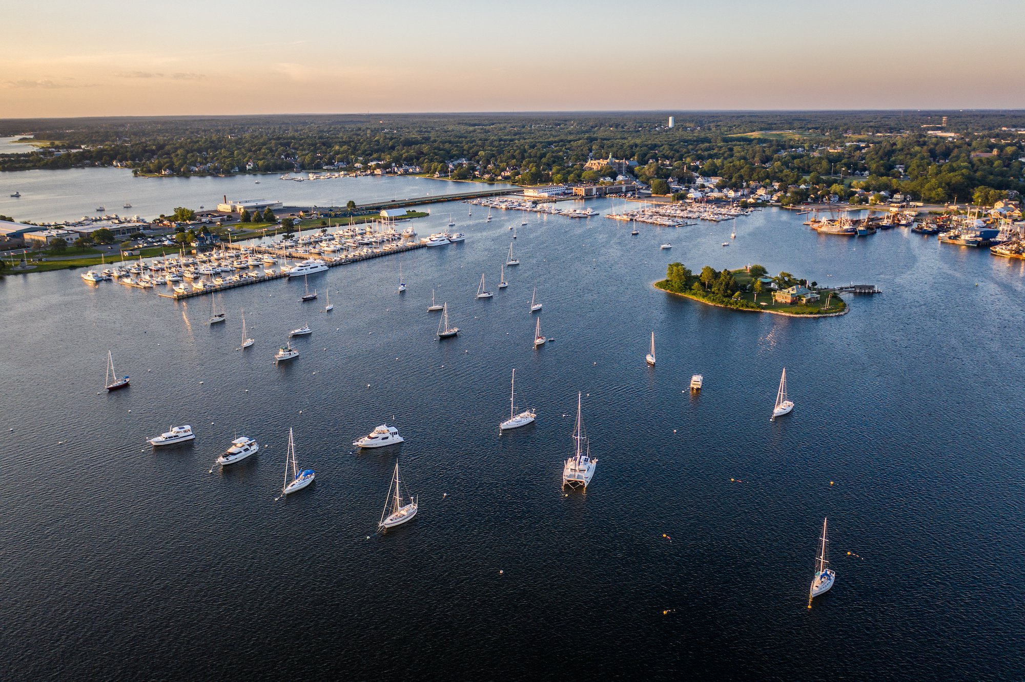
New Bedford is a historical and cultural hub in the heart of the South Coast that was once the whaling capital of the world. The small city is now home to the highest earning fishing port in the country, with annual revenue of $11 billion. Fairhaven, famously tied to Herman Melville and the whaleship Acushnet, has developed an economy that supports many of the fishing, ferry and recreational vessels around the port.
Massachusetts state planning recommendations for sea level rise projections under a high emission scenario mean that the South Coast of Massachusetts, which includes New Bedford and Fairhaven, would experience 1.2 feet of sea level rise by 2030, 2.5 feet by 2050, 4.3 feet by 2070 and 7.8 feet by 2100. For more than 50 years, the New Bedford Hurricane Barrier—which has been called a “18,000-foot-long insurance policy against tidal flooding”—has provided New Bedford residents with a sense of security. And though it has done its job to protect against many hurricanes and storms since 1966, the Hurricane Barrier has not yet been tested with the kind of storm it was designed to withstand, a 1938-esque Category 3 hurricane. What that means for the future of the port and neighboring communities remains to be seen.
In addition to the threats of climate change and sea level rise, New Bedford and Fairhaven are facing major challenges with affordable housing and gentrification, waste management and ecosystem health. Other priorities for many local leaders are the transition to clean energy, primarily the balance and harmonious coexistence of the fishing industry and the offshore wind industry, development vs. greenspace, storm and wastewater management.
Set against the backdrop of social and environmental inequities, along with the current and future impacts of climate change on all systems and people, these communities are undoubtedly living in a moment of transformation. This transformation will require both a recognition of the changing landscapes we inhabit, as well as the need for new strategies to ensure an equitable and effective transition to the future. How can a design studio reimagine the social, ecological and economic relations embedded in design to challenge the status quo and meet the needs of the community? How will the many diverse communities with their own values adapt? How might the innovative design thinking of students help business owners, fishermen, families and residents consider adaptive waterfronts that embrace healthy, sustainable and equitable systems around water?


Selected Sites:

North End
The Port of New Bedford

South End

Fairhaven

The Town of Fairhaven is currently in the midst of preparing a 40R Overlay District Bylaw with Design Standards for its 2023 Annual Town Meeting Warrant. The Planning Department last summer put together a working group in an effort to ensure that community members, local business owners and residents are represented during the process. The new zoning designation, known as “smart growth”, would be an overlay district that would allow for a wider variety of mixed uses. It would allow Fairhaven to zone for higher-density residential and mixed-use development by offering financial incentives and control over design.
Currently, several areas in Fairhaven are being considered to be part of the overlay district, most notably the outdated commercial center/shopping plazas. The idea behind the 40R is to stimulate not only more economic opportunity in Fairhaven, but to also provide additional affordable housing—for those new families, adults entering the workforce and even for retirees who wish to downsize but want to stay in Fairhaven.
Fairhaven
Across the harbor from New Bedford sits Fairhaven, which separated from New Bedford in 1812. Its historic downtown houses cafes, churches and a maritime institute. It connects with neighboring communities via a scenic, 4.5-mile bike path that runs parallel to Route 6. A community of 16,094 residents, Fairhaven faces many of the same environmental challenges that its neighbor does. With a projected 1.2 feet of sea level rise by 2030, 2.5 feet by 2050, 4.3 feet by 2070 and 7.8 feet by 2100, risk to local infrastructure, roadways, homes and properties is only expected to increase in the coming years. And unlike New Bedford which benefits from hardscaping and hard armoring around its shoreline, the community of Fairhaven—which enjoys much more green space in wetlands and salt marshes—is largely exposed to incoming storms and tidal surges.
From the whaling industry to today’s fishing industry, Fairhaven has long supported the maintenance, construction, servicing and storage of vessels driving the local economy—from the whaling oil of the past to the cod and scallops of today to the future of offshore wind. Through the town’s history of whaling, Fairhaven has been home to whalers and fisherman from around the world. One such example is the Japanese sailor Manjiro who was rescued at sea by Captain William Whitfield and made Fairhaven, MA his second home across the globe. Manjiro studied at the Old Stone School House, Fairhaven’s first school which was built in 1828.
Fairhaven is also the birthplace of Henry Huttleston Rogers, a businessman who made a fortune at Standard Oil with John D. Rockefeller. Rogers contributed greatly to the Fairhaven landscape by donating the Fairhaven Town Hall, High School, Unitarian Memorial Church, Millicent Public Library and more to the town. Each of these, palatial, Romanesque buildings were designed by Charles Brigham around the turn of the century and serve as statement pieces for the surrounding area. However, these buildings are all facing the wear and tear of age.
Community groups like the South Coast chapter of the Climate Reality Project, which formed in 2011, are working to spread community awareness around green legislature, as well as local actions relating to climate change. They run a renewable energy campaign to convince neighbors to go electric as well as a project intended to end plastic use (Fairhaven recently passed a ban on alcohol nips). The South Coast chapter provides interested parties with information on how to do one’s part to mitigate climate change impacts locally with educational materials on their website and in their newsletter. In the heart of Fairhaven Center is Northeast Maritime Institute—a contemporary school that works to educate candidates seeking their captain’s and seafarer’s license.
Cushman Park, once a swampy area by the name of Mill Pond that was filled in the early 1900s, is now a cornerstone of the Fairhaven neighborhood, close to the Town Center. When the pond was filled, parts of Bridge Street were raised, Park Avenue was laid out and the park was beautified. Today, it’s complete with fields, tennis courts, a track and playground. To the south sits Fairhaven Shipyard and the Fort Phoenix State Reservation—on the other side of the Hurricane Barrier. Within this neighborhood sit several cafes and shops, but mostly residential family homes. Though there is a slight incline as you head south toward Fort Phoenix, much of the area around Cushman Park, just below Route 6, is low-lying. Compared to its neighbor New Bedford, the area is largely green space with little hard armoring.
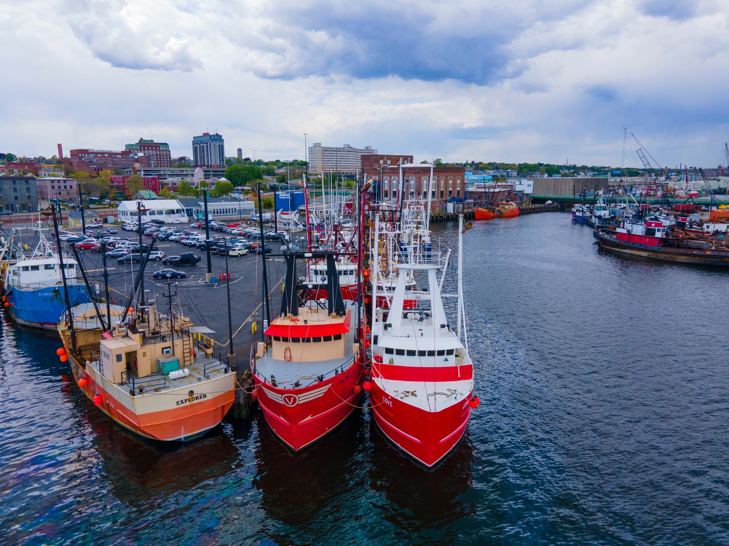
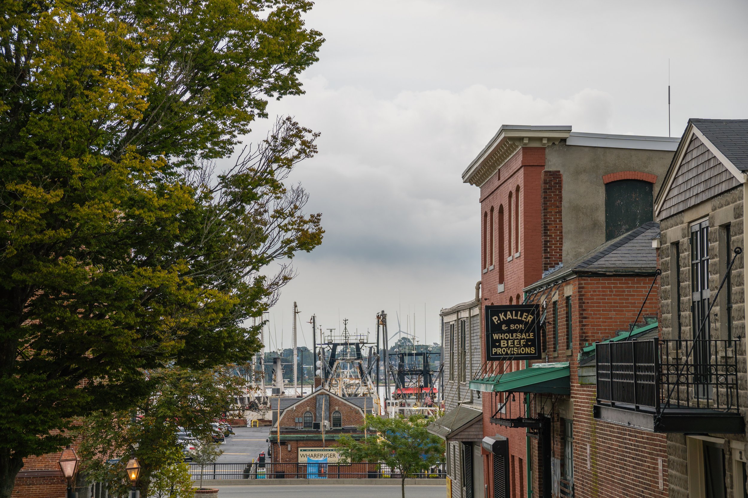
The Port of New Bedford
The No. 1 fishing port in America, the Port of New Bedford is the center of commercial fishing on the East Coast with annual revenue of $11 billion. It hosts a variety of industrial, commercial and recreational opportunities and remains an iconic culturally and historically significant working waterfront. In 1966, the U.S. Army Corps of Engineers (USACE) built the 5,800 foot long New Bedford Hurricane Barrier stretching across the ocean from the south end of the city to the Town of Fairhaven. With a maximum elevation of 20 feet and a 150-foot-wide gate, the barrier remains open for commercial and recreational navigation until tides, coastal conditions or storms require the gates to be closed. This barrier ensures safety for vessels during storms and hurricanes, making New Bedford Harbor one of the safest hubs on the Eastern Seaboard. However, with additional traffic coming from offshore wind development and tourism on top of current fishing boats and Community Boating’s young sailors, the harbor will need to assess the need for a combined-use navigation plan to make sure the waters remain safe and accessible for everyone.
In 2019, the barrier was closed a total of 26 times. However, projections indicate that the number of instances in which the USACE needs to close the gate will continue to rise in coming years. While rising seas and intensifying storms are worrisome, the focus will likely be on the operation of the barrier that’s cause for concern—rather than the barrier itself. As conditions change and the impacts of climate accelerate, interventions to the barrier and to the systems that support and augment its effectiveness will need to be revisited. A one-of-a-kind structure, spare parts for the barrier would need to be crafted on an as-needed basis, meaning that any damage resulting in new parts would pose an enormous obstacle for the USACE and the barrier’s daily users.
How might a team suggest balancing modifications to the barrier with other innovative ideas that will help the community thrive longer? This delicate balance, evolving through time scales over the next 100 years will require much thought. In the near term, the priority for many local leaders is the successful transition to clean energy and the harmonious coexistence of the fishing industry and the offshore wind industry.


During New Bedford’s rise as the most successful city in the whaling industry in the early 1800s, immigrants from all over the world came to find work — both on the whaling ships that went out to sea as well as in the supportive industries back on shore. Large communities of people came from Cape Verde and the Azores, as well as from other European nations. Quaker influence ensured New Bedford was an abolitionist city that welcomed both free Black people and formerly enslaved. It was in the home of abolitionists Nathan and Polly Johnson on Seventh Street in New Bedford that Frederick Douglass first arrived and adopted the new surname, beginning his journey to become an internationally-renowned speaker and abolitionist. These populations remain today, along with many others that have immigrated from all over the globe, weaving together the vibrant and diverse community that exists today in New Bedford.
The North Bedford Historic District is a mostly residential historic district roughly bounded by Summer, Parker, Pleasant and Kempton Streets. Most of its development came during the 19th century. In February 2022, it was announced that the commercial area of Acushnet Avenue was one of 13 in the state selected to receive funding for economic development initiatives. As part of MassDevelopment's Transformative Development Initiative (TDI), a program to advance economic growth of specific commercial districts in 'gateway cities,' or former urban industrial centers, the district will receive part of the $23.7 million in total state funding. This is the second designated TDI district in New Bedford in recent years.
Local organizations have been investing in the North End for a long time. The Community Economic Development Center (CEDC), a non-profit organization dedicated to enabling opportunity for all segments of society, purchased the former Capitol Theater on Acushnet Avenue with plans to rehabilitate the building for adaptive reuse, in partnership with Waterfront Area Historic League (WHALE). The two groups plan to adapt the Capitol Theater into office space, affordable housing units and street level retail. It will also include a new home for the CEDC with enhanced economic development and vocational programming.
What are the challenges related to climate, sustainability and equity? How can design studios think about the development of affordable housing as part of the broader movement for environmental, racial and economic justice?
North End


South End
South of I-195, Route 6 and downtown New Bedford is a peninsula surrounded by three miles of accessible shoreline known as the South End. Largely residential, the neighborhood is home to Fort Taber (or the Fort at Clark's Point) and like most of New Bedford has seen decline and renewal over the decades. It was once home to the Potomska and Berkshire Hathaway Mills and the now-abandoned Orpheum theater adjacent to Route 18. A number of public investments and initiatives have helped to drive economic growth in the neighborhood. Currently underway is the West Rodney French Boulevard project, which includes the revitalization of the Kilburn Mill with the goal of improving quality of life in the South End through improved mixed-use spaces, greater accessibility to businesses and recreational activities. Another consideration is how to help mitigate the issues created by the construction of the highway and how to create a better connection and increased accessibility to the waterfront for all residents to enjoy.
The South End also boasts the Blue Lane, a contiguous set of recreational pathways atop the city’s hurricane barrier. The CoveWalk and HarborWalk run along the South End peninsula and will eventually connect to the planned RiverWalk on the banks of the Acushnet River in the North End. The project has increased access and recreation as well as connectivity along the city’s waterfront.
The community group, Youth Opportunities Unlimited (Y.O.U.) is using grant money to install an automatic weather station at the Victory Park Children’s Garden and equip student bikers with handheld instruments. These young scholars will then be able to supply real-time data to scientists and meteorologists as they ride their bikes around the South End.
Much of the South End neighborhood sits outside of the hurricane barrier, which opens and closes at two locations across the roadway: Rodney French Blvd and West Rodney French Blvd. In recent years, the Federal Emergency Management Agency re-mapped and expanded New Bedford's flood plain. The entire outer edge of the peninsula becomes a FEMA Flood Insurance Floodplain Zone for a 1% Flood Zone VE: Coastal areas with a 1% or greater chance of flooding and an additional hazard associated with storm waves. These areas have a 26% chance of flooding over the life of a 30‐year mortgage. At present, residents remain relatively safe, but aging infrastructure needs evaluation and a game plan moving forward.
New Bedford Maps


Fairhaven Maps


New Bedford and Fairhaven Historic Photos


Sources
The study area problem statements were developed based on conversations with New Bedford and Fairhaven stakeholders that took place in the fall of 2022, supplemented by additional resources listed.
https://www.nps.gov/nebe/learn/historyculture/africanamerican.htm
https://nbedc.org/a-capitol-investment-in-new-bedfords-north-end-2/
https://www.nae.usace.army.mil/Missions/Civil-Works/Flood-Risk-Management/Massachusetts/New-Bedford/
https://climate.buzzardsbay.org/nbh-floodplain-expansion.html
https://www.savebuzzardsbay.org/news/marsh-island-salt-marsh-restoration-begins/